

Significant Winter Storm in Northern Iowa, Snow in Central Iowa
- Trey's Weather on the Web

- Dec 9, 2021
- 3 min read
OVERVIEW/IMPACTS:
A strengthening upper level storm system moving into the West Coast states early Thursday will eventually develop into a powerful winter storm to affect parts of Central and Northern Iowa beginning Friday mid-morning and last through early Saturday. Significant snowfall accumulations and gusty winds will lead to blowing snow and reduced visibility--especially along and north of HWY 20 from mid Friday afternoon through Saturday morning.
NWS Des Moines ALERTS (As of 1am Thursday):
WINTER STORM WATCH in effect from 12PM Friday to 6AM Saturday for the following counties: Emmet, Kossuth, Winnebago, Worth, Palo Alto, Hancock, Cerro Gordo, Pocahontas, and Humboldt counties.
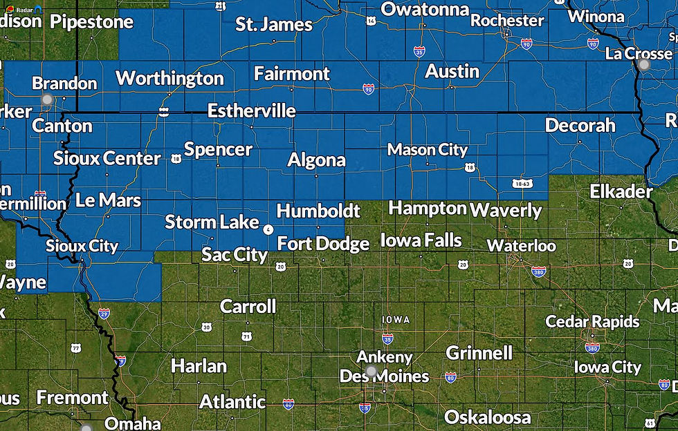
***These areas will likely be upgraded to a warning some point on Thursday and additional warnings and advisories may be needed elsewhere.
METEOROLOGY AND STORM SETUP:
Latest water vapor imagery from GOES-17 is finally beginning to show the shortwave trof that will eventually consolidate with another upper low west of Baja California to become a powerful mid-latitude storm system to sweep across the CONUS later this week into the weekend. The two features are projected to merge over New Mexico/Colorado. Two jet streaks--one back loaded with the system moving into the Rockies and another front loaded with the system coming from Baja (helping to lift this shortwave northeast) will merge and help propagate the newly consolidated shortwave. Strong positive vorticity advection and upper level divergence will lead to rapid surface cyclone genesis over Eastern Colorado late Thursday night and Friday morning. The surface cyclone will likely dip southeast following a region of warmer, moist air for diabatic heating before lifting east and then northeast toward Northeast Kansas and Northern Missouri following a northward lifting warm front.
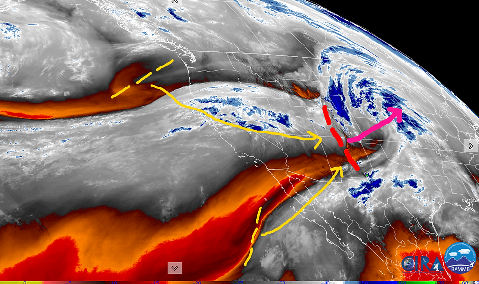
As the upper trough moves east, it will initially be positively-tilted (northern end leaning to right) before it takes on a neutral to even slightly more negative tilt. Large scale models have caught on with this trend since earlier in the week, which means that this will likely end up resulting in a deeper surface low. More positive vorticity advection PVA combined with the jet streak working through the base of the trough will lead to rapid rising motion over the Missouri/Upper Mississippi Valley.


With a deeper surface low from the enhanced upward motion, this raises the likelihood of more warm, moist air advection into the surface low which means as that air is lifted into the cold sector of the system--atop the cool conveyor, we will a narrow, focused area of enhanced vertical motion leading to a band of heavier snow. The temperature profile of the atmosphere will be supportive of all snow north of HWY 20, with temperatures below freezing through the entire profile. However, some of the latest high-res guidance coming in indicate a small zone roughly near HWY 30 to I-80 where we may see some freezing rain and or sleet as that warm nose works in from the southeast thanks to the deeper low pressure system. As surface low pulls away from the region during the predawn hours of Saturday, additional moisture is likely to wrap back around the surface low, and with the westward tilted nature of the upper level storm system, this will likely lead to snowfall wrapping back around to the west and southwest--getting areas that were not previously receiving snow during the morning-afternoon hours of Friday.


Winds will also be a big issue as well leading to blowing snow and reduced visibility. Gusts may reach 35-40mph, with sustained winds of 20-30mph--just shy of blizzard criteria in some areas. The gustiest wind will occur Friday night into Saturday morning on the back side of the surface low.
SNOWFALL AMOUNTS:
My first snowfall forecast is still in relatively consisted thinking from what has been indicated for much of the week. Highest totals are expected to occur over far northern and northwest Iowa where a swath of 6-8" + is likely. This is where models are fairly consistent in developing a band of very heavy snowfall due to frontogenic forcing and where the dry trof aloft may also play a role in setting up the initial snow band. Farther south, 4-6" of snow is likely along and north the HWY 20 corridor. Forecast snowfall amounts become less farther south due to a shorter duration of snow and the potential for temperatures to be near or above freezing at the onset of the event. Eventually snow will wrap back around the surface low leading to an inch or two even down to the I-80 corridor. Most models are in fairly decent agreement on the placement of the snowfall, except the EURO which brings slightly heavier totals south well into the Des Moines area and even southwestern Iowa. Even if this scenario were to result, amounts would only be 1-2" higher than the current forecast.

Stay tuned for updates as I will likely release two additional snowfall forecasts later on Thursday and again Friday morning before the onset of the storm.


Comments