

Forecast Discussion: Central/East Iowa Accumulating Snow February 8-February 9
- Trey's Weather on the Web

- Feb 7, 2023
- 4 min read
Updated: Feb 8, 2023
Overview: A complex forecast scenario more typical of the transition season between winter and spring is ahead for Central and Eastern Iowa. A potent storm system lift north into the Mid-Mississippi Valley bringing the likelihood of a lot of rain but what is less certain at this time is the quantity and intensity of snowfall.
Synoptic Setup:


The system that will eventually move our direction late Wednesday night into predawn Thursday is currently in the Desert Southwest/Rocky Mountain states. This system is taking on an orientation of an elongated, positively-tilted trough as the northern portion of the jet stream accelerated leaving this cold pocket of air aloft behind. A second shortwave trough and its associated jet streak are moving into the Pacific Northwest midday Tuesday and will soon dig into this already established trough. As this jet steak digs into the pre-existing trough, it will enable it to amplify and tilt more rearward. In addition to that, the jet streak leading the current positively-tilted trough will help to lift and steer this system more northeast toward the Mid-Mississippi valley as opposed to causing it to dig farther and bypass to the south. Models are in very strong agreement of that this trough will take on a negative-tilt as it move northeast toward the Missouri-Iowa-Illinois tri-state area by the predawn hours of Thursday.
Cooling the atmosphere for snow despite unseasonably warm temperatures:


This will not be a typical setup for our area for early February, primarily due to the lack of antecedent cold air through much of the lower levels of the atmosphere. The polar jet stream has been displaced well to our north since the end of last week, allowing a flood of milder air to move in from the west leading to days of unseasonably warm temperatures even leading up to tomorrow's storm system. The atmosphere can induce its own localized cooling however via dynamic forcing and melting, which is what we're going to see tomorrow. As the shortwave takes on a negative tilt moving into our region, that will maximize the amount of positive vorticity advection over the lower level low pressure center allowing it to intensify and increase advections and upward motion. The upward motion induced will cause an expansion and cooling of air over Northern MO, IA, WI enough to lower most of the column temperature of the column of air to support snow. Advection, or horizontal transport of air will also play a role (smaller) as well once the low deepens and can pull some colder air from the north. Melting snowflakes falling into the warmer layer will also invoke some cooling as well.
Temperature profile, Banded Precipitation, and additional analysis:

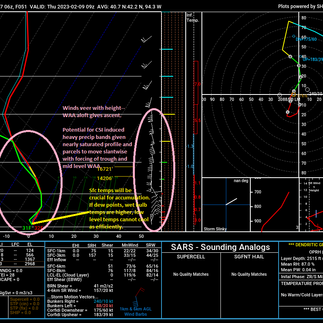


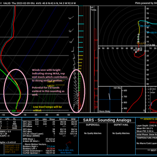
The most critical part of this forecast will be the lowest level temperatures as this will have a big impact on accumulation potential. Surface dew points will likely be hovering around the 31-32 deg F range, which places a cap on how much cooling can actually occur in the low levels and at the surface. If dew points say, were in the 26-28 degree range, the atmosphere would be relatively drier and more evaporation could occur at the onset of this event to force air temperatures to drop. With an already saturated profile aloft and relatively high dew points down low, we will likely not be able to achieve much cooling with temperatures only to hover around the 32-33 deg F range. Despite that, snow can still occur and it can really accumulate thanks to another process called Convective Symmetric Instability. This can lead to bands of very heavy snow, so despite surface temperatures being borderline conducive, accumulations can locally stack up. Convective symmetric instability happens when the atmosphere is deemed unstable not by air rising vertically or moving horizontally, but moving in a slantwise, sloping fashion as air moves up and across a sloping temperature gradient in a SATURATED or NEARLY SATURATED atmosphere. NWS Des Moines mentioned the potential in this morning's area forecast discussion, so this is something that we'll have to monitor between midnight and 8AM Thursday.
Snowfall amounts and factors going into this forecast:


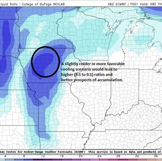

If cold air wasn't a limiting factor, this would be a massive snowstorm (probably the most intense this season) for our area. But we can't have nice things anymore :) With warmer low level temperatures and the prospect of melting, this is going to significantly "eat" away at the potential for massive accumulations. Model snow-liquid ratios are in line for 7:1 to 8:1 event for our area. A higher end scenario would be potentially some of our northeastern zones ending closer to a 9:1 snow-liquid ratio where temperatures may be colder. With this in mind and the potential for melting, I've gone with a 2-4" contour along the I-35 corridor including the Des Moines metro, with amounts steadily tapering off farther west. The higher accumulations will likely exist roughly from near or just south of I-80 from Jasper county east to the Iowa City area and points northeast where 4-6" appear possible. Locally higher amounts are possible, especially if those CSI induced bands really start to crank out snowfall rates. I will be closely monitoring temperature and dew point trends in next 24 hours. Should we trend slightly drier and cooler, these amounts will likely need to be increased.


Comments