

Ending June on a Hot Note, July Starts As You Would Expect It; Heat Relief Next Week
- Trey's Weather on the Web

- Jul 1, 2018
- 3 min read
Today is the last day of June, and we are wrapping up the first month of meteorological summer on a hot note. Twenty-six out of thirty days this month feature high temperatures ABOVE normal, with only two below normal and two at normal. We also ended the month more than 2" BELOW NORMAL on rainfall which is not good news, especially with our growing drought concerns.
SHORT TERM: Sunday-Tuesday:
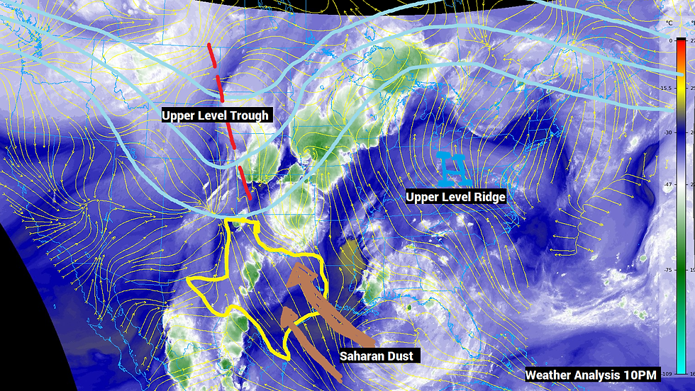
July will begin as you would typically expect it--typical heat and humidity. The good news is for at least the next 24 hours, the core of the upper level ridge (where the greatest subsidence and heat core are located) will be centered across the Eastern U.S. Rotating clockwise around this ridge into North TX is some tropical moisture along with Saharan (yes from Africa) dust into our area. It is not uncommon this time of year for the remnants of large dust storms in the Saharan Desert to get caught up in the easterly trade winds and blow toward the North American continent. Good news--this dust helps to dry out the atmosphere and acts as hostile ingredient toward the development of tropical storms and hurricanes, so at least those concerns won't exist in the near future. We should eventually begin to pull out of the dust by early next week as the upper level ridge becomes more elongated and expands across much of the Continental U.S. We will still be influenced by the ridge in North TX with very hot afternoon high temperatures tomorrow through Tuesday. Do not be surprised if we rack up another three days in a row of triple-digit temperatures before some heat relief arrives in time for the Fourth of July. There is a low chance of an isolated storm across counties to the NW of DFW and along the Red River.

LONG TERM: Wednesday-End of Next Week
By the middle of next week, the ridge of high pressure will be centered across the Midwest States. With the ridge centered north of North TX, this means the core of the heat will actually NOT be on top of us, and we will see somewhat of a strange weather pattern in which all of our moisture/clouds/precipitation will come out of the EAST as opposed to the traditional west to east or northwest to southeast that we are accustomed to seeing. The clockwise flow around the ridge of high pressure will bring some upper level disturbances to trigger showers and storms starting next Wednesday (4th of July). There will be at least two potent disturbances, the first of which will arrive on Wednesday from the east. Based on current model guidance the core of the disturbance will likely end up going just south of North TX, which means the most widespread rain chances will be down to the southeast and closest to the coast. More isolated to scattered air mass showers and storms will be commonplace here next Wednesday-Friday, but if we get more influence from the upper level low, then these rain chances could increase.


Due to the increased tropical moisture, more clouds, and scattered rain chances, high temperatures by the middle of next week will be slightly cooler. Instead of upper 90s and triple digits, expect highs in the low to mid 90s with lows in the mid to upper 70s. Of course, this is only temporary as the hottest weeks of the year, climatologically speaking, are just around the corner.


Comments