

Central Iowa: Weekly Weather Rundown January 28, 2019--EXTREMELY DANGEROUS & LIFE-THREATENING COLD
- Trey's Weather on the Web

- Jan 29, 2019
- 3 min read
The coldest air mass so far this winter and in years is poised to move into Central Iowa beginning late Tuesday lasting through the end of this week. The coldest of the cold will likely be from late Tuesday through Thursday afternoon as air temperatures will likely remain below zero in Des Moines from late Tuesday evening through Thursday afternoon. Locations to the north will likely be below zero for a much longer period of time.
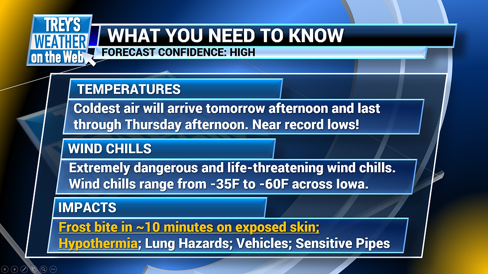
A Wind Chill Warning is in effect for all of Central Iowa. The warning expires at various times depending on your specific county, but to keep things simple, just know the most dangerous cold will be late Tuesday through Thursday afternoon.


FORECAST, SETUP, TIMING:
For Tuesday, expect morning temperatures to hover in the low single digits across Central Iowa, but steadily fall to near zero and a few degrees below, especially after the noon hour as a reinforcing shot of arctic air arrives with the incoming lobe of the Polar Vortex and an associate arctic front. To make matters worse, winds will be quite breezy out of the northwest ranging from 15-25MPH making actual wind chill values much lower than the air temperature.

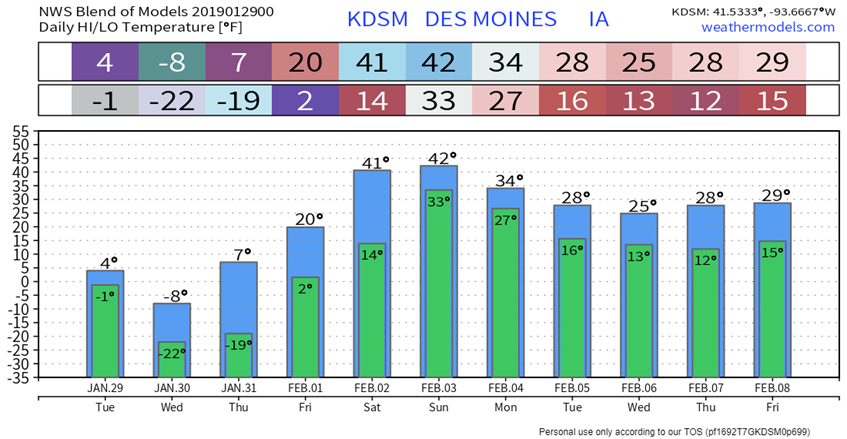
Overnight Tuesday into Wednesday will likely feature the lowest wind chills and lowest temperatures in Central Iowa with temperatures ranging from -20F to -30F on Wednesday morning. The record low for Des Moines is 17F, so there is a high probability that this low will be broken. In terms of wind chills, expect wind chill values to range from -30F to -55F across the state Wednesday morning, which will be extremely dangerous and life-threatening to those outside for long periods of time.
Expect high temperatures on Wednesday to stay at or below zero across the entire state with dangerous wind chill values to continue.
As we head into Wednesday night and Thursday morning, surface wind speeds will likely decrease as a surface high pressure moves into the region, but as winds decrease and skies clear atop an existing snow pack with strong radiational cooling and cold air advection, expect lows once again to drop to near -20F across much of the state.
By Thursday afternoon and evening, the most intense duration of cold will slowly diminish as winds begin to shift to the south allowing for strong warm air advection to take hold of our pattern. Strong southerly winds into Friday will bring a decent warm up with highs in the mid 20s to low 30s on Friday afternoon and 40s for this upcoming weekend. This warm weekend will also allow for some melting of the existing snow pack, so expect muddy ground and street surfaces.

This warm up will not last long, as we will be back to cold temperatures and more wintry precipitation by the middle of next week.
COLD TEMPS SEEN ON INFRARED SATELLITE
The lobe of the Polar Vortex expected to bring record cold can be seen on Infrared Satellite Imagery this evening travelling south through Canada. Typically, Infrared Satellite is used to detect the temperatures of cloud tops. Cloud tops that receive strong and cold returns from IR Satellite Imagery are typically those associated with deep convection as the tops of the cumulonimbus clouds can reach tens of thousands of feet into the atmosphere where the temperature decreases substantially with height. This time however, we are able to detect cold temperatures at the surface using Infrared Satellite Imagery. Since the surface across southern Canada is so cold with approaching arctic air mass, infrared satellite can detect it and displays it as if there were clouds in place. It can easily be seen, however, that this is not cloud cover due to the slow expansion and "relatively" slow movement of this cold air mass compared to the streaky clouds seen in other places.


Komentar